Tag Archive | Volcano

Mt. St. Helen’s

Vancouver, Vancouver! This is it!

May 18, 2021

There are only a very few days in our lives which we recall with complete clarity. One’s wedding day, the birth of a child, the death of a loved one. There are also days which are touchstones because they affect so very many people. December 7, 1941. September 11, 2001. May 18, 1980.

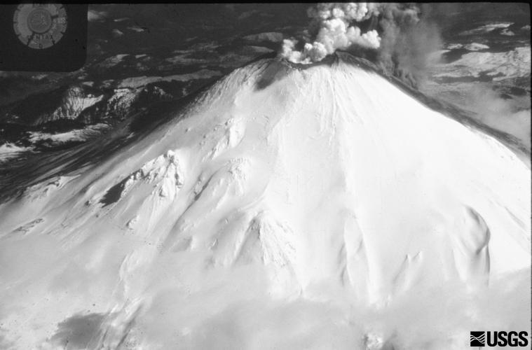
The last date was, particularly for those of us living in Washington and Oregon, the day when we understood the terrible, yet awesome, power of nature. In less than two minutes, the top 1,314 feet of Mount St. Helen’s was blasted away and swept down the north face of the mountain, leveling everything in its path.

Photographer Keith Ronnholm was in the right spot at 8:32 a.m. on May 18, 1980 when he captured the eruption in a series of still shots.

From the Infallible Wikipedia:

“The landslide exposed the dacite magma in St. Helens’ neck to much lower pressure, causing the gas-charged, partially molten rock and high-pressure steam above it to explode a few seconds after the landslide started. Explosions burst through the trailing part of the landslide, blasting rock debris northward. The resulting blast directed the pyroclastic flow laterally. It consisted of very hot volcanic gases, ash and pumice formed from new lava, as well as pulverized old rock, which hugged the ground. Initially moving at approximately 220 miles per hour (350 km/h), the blast quickly accelerated to around 670 mph (1,080 km/h), and it may have briefly passed the speed of sound.

Pyroclastic flow material passed over the moving avalanche and spread outward, devastating a fan-shaped area 23 miles across by 19 miles long (37 km × 31 km). In total about 230 square miles (600 km2) of forest was knocked down, and extreme heat killed trees miles beyond the blow-down zone. At its vent the lateral blast probably did not last longer than about 30 seconds, but the northward-radiating and expanding blast cloud continued for about another minute.

Superheated flow material flashed water in Spirit Lake and North Fork Toutle River to steam, creating a larger, secondary explosion that was heard as far away as British Columbia, Montana, Idaho, and Northern California.”

This is the scientific description of what happened. The only way to describe that day on a personal level was ‘surreal.’

At 8:32 a.m. the hubby (he was the fiancé on that day) and I had just awoken. We were up in Blaine, Washington, the last town (population 2,683 in 1980) before crossing the border to British Columbia.

We had been there since Friday night when we arrived and sat in the family kitchen and announced our engagement. The weekend had been spent visiting, playing cards, and hanging out. The hubby and I were to leave in the early afternoon and head to Seattle where he lived. I would have to head further south to Eatonville.

But I digress. 8:32 a.m. and there are two loud ‘claps’ and the walls of the house shudder. I’m thinking earthquake or, possibly, that the bull my future father in law kept out in the field, had escaped and was ramming the house. This was not an impossibility since it had happened once before.

I say to my hubby, “Maybe the bull got loose.” But his reply is prescient when he says “It’s Mount St. Helen’s.”

It was nearly two hours before his words were proven true and the TV news stations began showing video of the nearly 80,000 foot ash plume soaring above the now sheared mountain. Planes flew over the Toutle and Cowlitz rivers with photographers filming entire houses and forests being swept down the rivers, taking out bridges and all vegetation in its path. We were glued to the TV.

I had but one thought, I needed to get back to Eatonville as I was the sole reporter for the weekly paper and – although the community was not in the path of the ash cloud – being less than 60 miles from the mountain, it WAS the news story of the week, perhaps the year or even the decade.

That evening, after checking in with the publisher and working on a story for the paper to be included in the layout the next day, I was at my apartment fixing myself some dinner. I turned on the TV – KOMO 4 – and at first I thought something was wrong with the TV. It was a hand-me-down, early 1960’s, black and white which had been my grandmother’s TV when she was still alive.

All I could see on the TV was a black screen with a smudge of white appearing every so often. But it wasn’t the fact that there wasn’t much picture so much as what I was hearing. It became evident quickly that I was watching a film from someone who had been caught in the eruption. Someone who wasn’t sure if they were going to live or die. It was riveting. I later learned that the person was Dave Crockett and he did survive. But 57 others did not that day.

In the summer of 1985, the (now) hubby, me, my Mom and Dad, drove to Mt. St. Helen’s and along the forest service roads on the east side of the mountain. Nothing had yet been developed. There wasn’t a visitor centers or restroom. Just a few Honey Buckets set up where the crowds had organically gathered. We stopped at a pond where every tree surrounding it had been blown down or broken. Yet, new sprouts had started to grow, and tadpoles skittered through the shallows.

The pyroclastic flow tossed the trees around like toothpicks, laying them out in swirl patterns
I’ve always wondered about the occupants of this car and their last terrifying moments.

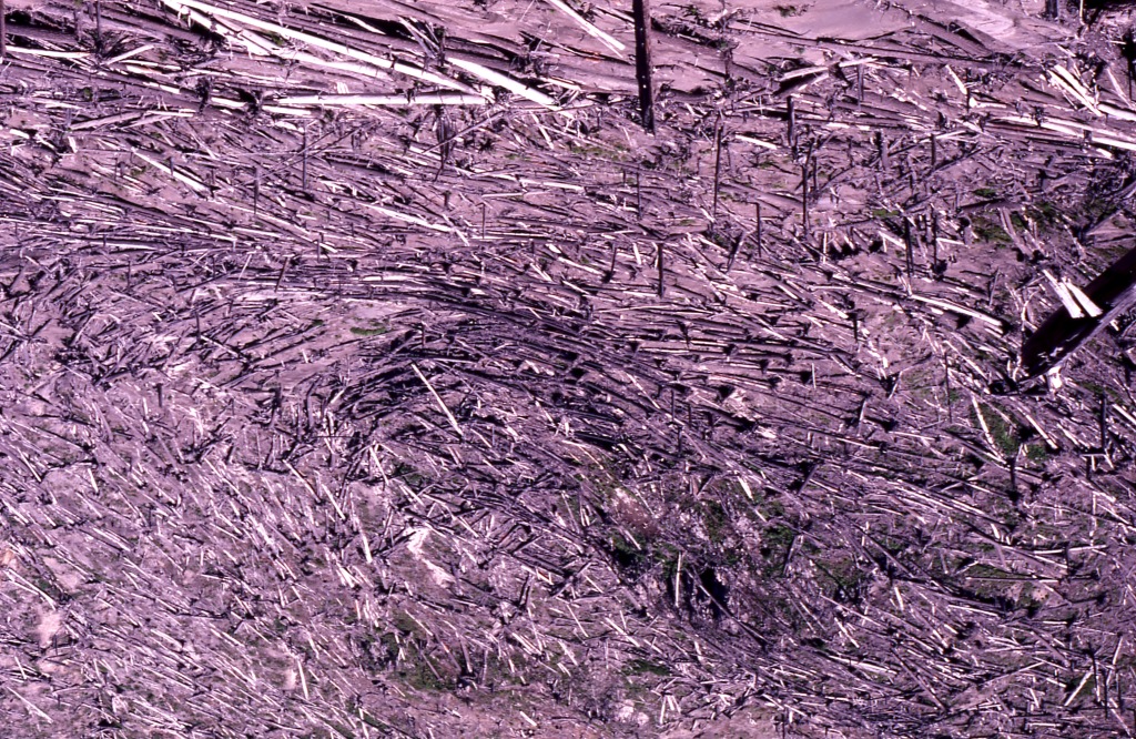
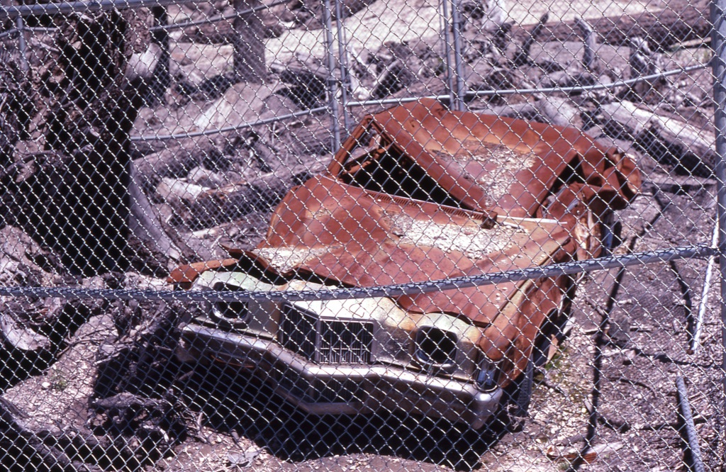
We saw a destroyed car, a sad monument to whoever was caught behind the wheel. We stood below the mountain and looked up in amazement at miles of the once 70 to 80 foot tall trees now scattered across the landscape like some giants’ game of pick-up sticks.

We stopped on a ridge to the northeast of the mountain and gazed down at a log clogged Spirit Lake and into the steaming crater of the mountain.

At the time – as is so often the case – we didn’t fully appreciate that the sites we saw that day would soon be gone, changed by snow and sun, rain and wind, and the regeneration of life.

A pond regenerates after the blast
My parents during the 1985 tour of Mt. St. Helens. They had been plunged into volcanic darkness in Yakima five years earlier the morning the mountain erupted.

Every year on May 18 I pause and reflect on the events of that day, still as clear in my mind as if it was last week. Mt. St. Helen’s eruption changed me; in so many imperceptible ways it marked the moment when I began to view the world from an adult perspective, recognizing there are forces in the universe over which neither I nor anyone else has control.

Mt. St. Helen’s made me more cautious and more aware of the transitory nature of life. But it also brings to mind the phrase from the Roman poet, Horace, ‘Carpe Diem.’ Every day is the right day to do just that. Go seize yours.

The links:

https://en.wikipedia.org/wiki/1980_eruption_of_Mount_St._Helens

https://petapixel.com/2013/02/26/photographing-the-eruption-of-mount-st-helens-from-10-miles-away/

Glacier Peak, Washington

June 12, 2018

The Volcano That Get’s No Respect

One night – a month ago in early May – the news that Kilauea volcano in Hawaii had erupted dominated the news. Reports on the lava flows and subsequent explosive discharges provided our TV stations in Western Washington an opportunity to remind all of us that there are five active volcanoes in the state.seattle with glacier peak

“Five?” I exclaimed to my hubby as we sat in the living room of our new Mount Vernon, Washington, condo. “I dispute that there are five ACTIVE volcanoes here!”

Of course such a claim sent me straight to the internet.

I knew of the two obvious active ones: Mt. St. Helen’s and Mt. Baker as both had activity in the past 40 years. And you can hardly read anything about Mt. Rainier without being reminded that although it is dormant it’s not dead and ‘could’ erupt this week or not for a thousand years.

Which left ‘two’ unaccounted for volcanos. The first one was easy: Mt. Adams. I grew up seeing Mt. Adams on most days from Yakima. But it has always been my understanding that it is not in any danger of eruption as it truly is a long dormant mountain.

So what was the last volcano? In addition to Washington’s four mountains, there were Mt. Hood in Oregon as well as the Three Sisters and then two in California, Shasta and Lassen Peak.

I was, frankly, a veritable volcano snob, having not only lived through the eruption of Mt. St. Helen’s but also growing up with the volcanic mountains so much a part of the experience. I know my mountains! But the gauntlet had been thrown down and I set out to disprove the report. There was not, I was certain, a ‘fifth’ Washington state volcano.

Imagine my dismay when, according to the infallible Wikipedia (as well as the US Geologic Survey), the benign sounding Glacier Peak turned out to be the missing volcano.

Glacier Peak!? I’d heard of it but the name alone reinforces visions of cold and ice. A volcano? It’s a volcano?

dakobedIndeed it is. At 10,541 feet it is the fourth tallest peak in the state and is located a scant 50 miles southeast from where I now live and only 70 miles northeast of Seattle.

And, like Volcan de Fuego in Guatamala and our other four peaks, it is a stratovolcano, the kind of volcano which can erupt violently.

From the infallible Wikipedia:

“Of the five major volcanoes in Washington, only Glacier Peak and Mount St. Helens have had large eruptions in the past 15,000 years. Since both volcanoes generate magma of dacitic origin, the viscous magma builds up since it cannot flow through the eruptive vent. Gradually, the pressure grows, culminating in an explosion that ejects materials such as tephra, which in its simplest form, is ash.

Tephrochronology and radiocarbon dating indicate that Glacier Peak eruptions occurred in 1700 AD ± 100 years, 1300 AD ± 300 years, 900 AD ± 50 years, 200 AD ± 50 years, 850 BC, 3150 BC, and in 3550 BC. The Volcanic Explosivity Index (VEI) for three of these was 2 to 4, small compared to the 5 of the 1980 eruption of Mount St. Helens. They were characterized mainly by a central vent eruption, followed by an explosive eruption. These eruptions varied in outcome; some produced lahars, some pyroclastic flows, and others lava domes.

A little more than 13,000 years ago, a sequence of nine tephra eruptions occurred within a period of less than a few hundred years. Associated with these eruptions were pyroclastic flows. Mixed with snow, ice and water, these formed lahars that raced into three nearby rivers, filling their valleys with deep deposits. Subsequently the mudflows drained into both the North Fork of the Stillaguamish River (at that time an outlet of the Sauk River) and Skagit Rivers. In Arlington, 60 miles downstream, lahars deposited seven feet of sediment. Subsequent erosion of lahar deposits near Darrington led to the current river system with the Stillaguamish River separated from the Sauk/Skagit Rivers. Lahar debris was deposited along both the Skagit and Stillaguamish Rivers all the way to Puget Sound. A small portion of the erupted tephra was deposited locally. However, most of the tephra reached higher levels of the atmosphere, and was transported by the wind hundreds of miles. Deposits from this congregation were as thick as 1 foot near Chelan and 0.3 inches near Missoula, Montana.

Since these events, Glacier Peak has produced several lahars. The largest events were 5,900 and 1,800 years ago and were associated with dome-building eruptions. In both cases, the lahars traveled down the Skagit River to Puget Sound.”

It was actually this last sentence which most caught my attention… I repeat:

In both cases, the lahars traveled down the Skagit River to Puget Sound.

Let’s see… where does the Skagit River flow before arriving at Puget Sound? Oh yes, I know, Mount Vernon.

lahar flows glacier peakArmed with this revelation about Washington’s mostly unknown volcano, my hubby will attest to the fact that I’ve become obsessed. In my weekly or more drives up and down Interstate 5 I have found myself, on clear days, scanning the mountains to the east. Which one is Glacier Peak? And, more importantly, how is it I never knew which one it was and that it’s a volcano?

I’ve come to believe that Glacier Peak is like the Rodney Dangerfield of volcanoes. It just doesn’t get any respect. There are no roads which will take you to its base. There’s no park, no visitor centers, no campgrounds. And every single day hundreds of thousands of people drive within less than a hundred miles of it, oblivious to its existence.

As an experiment I’ve started asking people two questions: first if they had ever heard of Glacier Peak and, second, that it’s a volcano. Consistently, the answer is no.

I’m now on a one-woman crusade to help Glacier Peak get that respect. It’s the least I can do for the volcano in my backyard.

Washington_State_volcanoesAs always, links to a couple of Infallible Wikipedia articles, USGS, and – for those of you under the age of 50 – Rodney Dangerfield. Gotta have those cultural references.

https://en.wikipedia.org/wiki/Glacier_Peak

https://en.wikipedia.org/wiki/Glacier_Peak_Wilderness

https://volcanoes.usgs.gov/volcanoes/glacier_peak/

https://youtu.be/Z_OuflwjeiY (Rodney Dangerfield YouTube clip)

A Blast From The Past

The Day Mt. St. Helen’s awoke

March 27, 2018

Mt. St. Helens March 1980It was on March 27, 1980, that the first plumes of steam escaped from Mt. St. Helen’s. Just over seven weeks later, the mountain experienced a 5.1 earthquake which caused the north side of the volcano to slide away and triggered the largest debris avalanche in recorded US history.

From the Infallible Wikipedia:

“The magma in St. Helen’s burst forth into a large-scale pyroclastic flow that flattened vegetation and buildings over 230 square miles. More than 1.5 million metric tons of sulfur dioxide was released into the atmosphere. On the Volcanic Explosivity Index scale, the eruption was rated a five, and categorized as a Plinian eruption.

The collapse of the northern flank of St. Helens mixed with ice, snow, and water to create lahars (volcanic mudflows). The lahars flowed many miles down the Toutle and Cowlitz Rivers, destroying bridges and lumber camps. A total of 3,900,000 cubic yards of material was transported 17 miles south into the Columbia River by the mudflows.

For more than nine hours, a vigorous plume of ash erupted, eventually reaching 12 to 16 miles above sea level.  The plume moved eastward at an average speed of 60 miles per hour with ash reaching Idaho by noon.”

This information is, of course, widely known. As a young reporter for the weekly Eatonville Dispatch in South Pierce County, Washington, that first puff of steam was part of a rather amazing life experience.

At a distance of only 47 miles – as the crow flies so to speak – from the mountain, Eatonville residents soon noticed fine layers of ash dusting the community. Week after week I wrote stories about the impact of the ash fall and provided reports in the paper as to all the latest activity.

The most interesting event, however, began two months earlier with a rather odd story told to me by a young couple who were driving home from Ashford to Eatonville one winter night. They claimed that they were followed by three bright orbs which sped up and slowed down in concert with their car. These young people were visibly upset by the incident and believed they had been followed by UFO’s. The photo here is NOT from that event but is illustrative of what they described.Blue glowing Orbs over Oakland, CA 2013

Another theory, however, was posited in late March in conjunction with the increased earthquake and volcanic rumblings. And that is the phenomenon known as Earthquake lightning. It is believed that lightning can be triggered by earthquakes and that, perhaps, the presence of these lights was associated with the impending eruption of Mt. St. Helen’s.

Also from the Infallible Wikipedia:

“The lights are reported to appear while an earthquake is occurring, although there are reports of lights before or after earthquakes, such as reports concerning the 1975 Kalapana earthquake. They are reported to have shapes similar to those of the auroras, with a white to bluish hue, but occasionally they have been reported having a wider color spectrum. The luminosity is reported to be visible for several seconds, but has also been reported to last for tens of minutes. Accounts of view-able distance from the epicenter varies: in the 1930 Idu earthquake, lights were reported up to 70 miles (110 km) from the epicenter.”

To this day I’ve never quite known what was or was not the truth with this account. I do know that when I was in the area where the phenomenon occurred in the two months prior to Mt. St.Helen’s awakening I was hyper aware and constantly scanned the rearview mirror for strange lights. I never did see any.

Dispatch article April 23 1980It was not until the April 23rd issue when I reported the first dusting of ash in Eatonville. Less than a month later the mountain blew.

As always, a couple of links:

https://en.wikipedia.org/wiki/Mount_St._Helens

https://en.wikipedia.org/wiki/Earthquake_light

Paricutin Pyroclastics

February 20, 2018

volcano 1943Geologically, nine years is a very short time period. But for farmer Dionisio Pulido of Paricutin, Mexico, the event which began at 4 p.m. on February 20, 1943, forever altered his life.

As he is quoted in the infallible Wikipedia:

“‘At 4 p.m., I left my wife to set fire to a pile of branches when I noticed that a crack, which was situated on one of the knolls of my farm, had opened . . . and I saw that it was a kind of fissure that had a depth of only half a meter. I set about to ignite the branches again when I felt a thunder, the trees trembled, and I turned to speak to Paula; and it was then I saw how, in the hole, the ground swelled and raised itself 2 or 2.5 meters high, and a kind of smoke or fine dust – grey, like ashes – began to rise up in a portion of the crack that I had not previously seen . . . Immediately more smoke began to rise with a hiss or whistle, loud and continuous; and there was a smell of sulfur.’

“He tried to find his family and oxen but they had disappeared so he rode his horse to town where he found his family and friends, happy to see him alive. The volcano grew fast and furiously after this.   Celedonio Gutierrez, who witnessed the eruption on the first night reported:

‘…when night began to fall, we heard noises like the surge of the sea, and red flames of fire rose into the darkened sky, some rising 800 meters or more into the air, that burst like golden marigolds, and a rain like artificial fire fell to the ground.’”

And thus began a eruption which provided scientists an opportunity to study and record how a  volcano is formed. During this time the volcano not only destroyed Pulido’s farm but forced the permanent evacuation of two towns, caused the deaths of three people (but not the farmer!), grew to 1341 feet, and allowed scientists to witness the entire life cycle of a volcano.

Also from the infallible Wikipedia:

“The importance of the Parícutin eruption was that it was the first time that volcanologists were able to fully document the entire life cycle of a volcano. The event brought geologists from all over the world,  but the principal researchers were William F. Foshag of the Smithsonian Institution and Dr. Jenaro Gonzalez Reyna from the Mexican government, who came about a month after the eruption started and stayed for several yeParicutinVolcanojpg-1552186_lg.jpgars. These two wrote detailed descriptions, drew sketches and maps and took samples and thousands of photographs during this time. Many of these are still used today by researchers. Foshag continued to study the volcano until his death in 1956. Between 1943 and 1948, almost fifty scientific articles were published in major journals about the volcano, with even more since. The worldwide effort to study Parícutin increased understanding of volcanism in general but particularly of scoria cone formation.”

As a child I have a distinct memory of sitting in a darkened classroom and watching a documentary about this event. In elementary school it was always a favorite moment when one of the Audio Visual (AV) helpers wheeled the tall cart into the classroom. Atop the cart was a black and white TV connected by wires to a 1960’s version of video equipment. Off would go the lights and some item of interest would flicker to life.School AV cart

As a child seeing a volcano literally grow out of the ground where nothing had been was terrifying. Could that happen in MY backyard? Being that my natural state was to worry about such things I’m pretty certain I was quite concerned  for my home. Over the years I, no doubt, saw dozens of programs this way but none ever made quite the same impression on me.

Thankfully Yakima was not prone to sudden volcanic eruptions and my family was able to live in blissful calm… until May 18, 1980. But THAT is a story for another day.

For those who want to learn more:

https://en.wikipedia.org/wiki/Par%C3%ADcutin

Not sure if this is the video I saw but the music alone is enough to instill terror into a child….

https://video.search.yahoo.com/search/video;_ylt=A0SO8zjY84paVDAA0RNXNyoA;_ylu=X3oDMTEzbGZiMWJ1BGNvbG8DZ3ExBHBvcwMxBHZ0aWQDVUlDMV8xBHNlYwNwaXZz?p=Paracutin+documentary&fr2=piv-