June 12th
A Tuesday Newsday Classic from 2018
One night – a month ago in early May – the news that Kilauea volcano in Hawaii had erupted dominated the news. Reports on the lava flows and subsequent explosive discharges provided our TV stations in Western Washington an opportunity to remind all of us that there are five active volcanoes in our state.

“Five?” I exclaimed to my hubby as we sat in the living room of our new Mount Vernon, Washington, condo. “I dispute that there are five ACTIVE volcanoes here!”
Of course such a claim sent me straight to the internet.
I knew of the two obvious active ones: Mt. St. Helen’s and Mt. Baker as both had activity in the past 40 years. And you can hardly read anything about Mt. Rainier without being reminded that although it is dormant it’s not dead and ‘could’ erupt this week or not for a thousand years.
Which left ‘two’ unaccounted for volcanos. The first one was easy: Mt. Adams. I grew up seeing Mt. Adams on most days walking to school in Yakima. But it has always been my understanding that it is not in any danger of eruption as it truly is a long dormant mountain.
So what was the last volcano? In addition to Washington’s four mountains, there were Mt. Hood in Oregon as well as the Three Sisters and then two in California, Shasta and Lassen Peak.
I was, frankly, a veritable volcano snob, having not only lived through the eruption of Mt. St. Helen’s but also growing up with the volcanic mountains so much a part of the experience. I know my mountains! But the gauntlet had been thrown down and I set out to disprove the report. There was not, I was certain, a ‘fifth’ Washington state volcano.
Imagine my dismay when, according to the infallible Wikipedia (as well as the US Geologic Survey), the benign sounding Glacier Peak turned out to be the missing volcano.
Glacier Peak!? I’d heard of it but the name alone reinforces visions of cold and ice. A volcano? It’s a volcano?
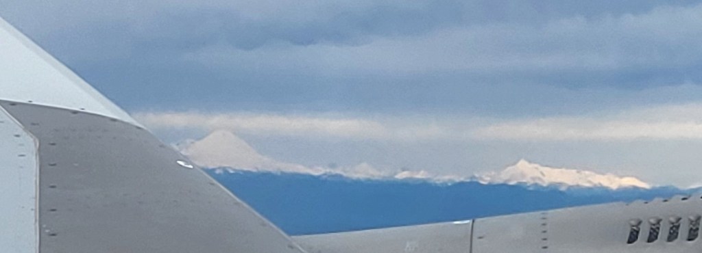
Indeed it is. At 10,541 feet it is the fourth tallest peak in the state and is located a scant 50 miles southeast from where I now live and only 70 miles northeast of Seattle.
And, like Volcan de Fuego in Guatamala and our other four peaks, it is a stratovolcano, the kind of volcano which can erupt violently.
From the Infallible Wikipedia:
“Of the five major volcanoes in Washington, only Glacier Peak and Mount St. Helens have had large eruptions in the past 15,000 years. Since both volcanoes generate magma of dacitic origin, the viscous magma builds up since it cannot flow through the eruptive vent. Gradually, the pressure grows, culminating in an explosion that ejects materials such as tephra, which in its simplest form, is ash.
Tephrochronology and radiocarbon dating indicate that Glacier Peak eruptions occurred in 1700 AD ± 100 years, 1300 AD ± 300 years, 900 AD ± 50 years, 200 AD ± 50 years, 850 BC, 3150 BC, and in 3550 BC. The Volcanic Explosivity Index (VEI) for three of these was 2 to 4, small compared to the 5 of the 1980 eruption of Mount St. Helens. They were characterized mainly by a central vent eruption, followed by an explosive eruption. These eruptions varied in outcome; some produced lahars, some pyroclastic flows, and others lava domes.
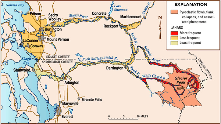
A little more than 13,000 years ago, a sequence of nine tephra eruptions occurred within a period of less than a few hundred years. Associated with these eruptions were pyroclastic flows. Mixed with snow, ice and water, these formed lahars that raced into three nearby rivers, filling their valleys with deep deposits. Subsequently the mudflows drained into both the North Fork of the Stillaguamish River (at that time an outlet of the Sauk River) and Skagit Rivers. In Arlington, 60 miles downstream, lahars deposited seven feet of sediment. Subsequent erosion of lahar deposits near Darrington led to the current river system with the Stillaguamish River separated from the Sauk/Skagit Rivers. Lahar debris was deposited along both the Skagit and Stillaguamish Rivers all the way to Puget Sound. A small portion of the erupted tephra was deposited locally. However, most of the tephra reached higher levels of the atmosphere, and was transported by the wind hundreds of miles. Deposits from this congregation were as thick as 1 foot near Chelan and 0.3 inches near Missoula, Montana.
Since these events, Glacier Peak has produced several lahars. The largest events were 5,900 and 1,800 years ago and were associated with dome-building eruptions. In both cases, the lahars traveled down the Skagit River to Puget Sound.”
It was actually this last sentence which most caught my attention… I repeat:
In both cases, the lahars traveled down the Skagit River to Puget Sound.
Let’s see… where does the Skagit River flow before arriving at Puget Sound? Oh yes, I know, Mount Vernon.
Armed with this revelation about Washington’s mostly unknown volcano, my hubby will attest to the fact that I’ve become obsessed. In my weekly or more drives up and down Interstate 5 I have found myself, on clear days, scanning the mountains to the east. Which one is Glacier Peak? And, more importantly, how is it I never knew which one it was and that it’s a volcano?
I’ve come to believe that Glacier Peak is like the Rodney Dangerfield of volcanoes. It just doesn’t get any respect. There are no roads which will take you to its base. There’s no park, no visitor centers, no campgrounds. And every single day hundreds of thousands of people drive within less than a hundred miles of it, oblivious to its existence.
As an experiment I’ve started asking people two questions: first if they had ever heard of Glacier Peak and, second, that it’s a volcano. Consistently, the answer is no.
I’m now on a one-woman crusade to help Glacier Peak get that respect. It’s the least I can do for the volcano in my backyard.

As always, links to a couple of Infallible Wikipedia articles, USGS, and – for those of you under the age of 50 – Rodney Dangerfield. Gotta have those cultural references.
https://en.wikipedia.org/wiki/Glacier_Peak
https://en.wikipedia.org/wiki/Glacier_Peak_Wilderness
https://volcanoes.usgs.gov/volcanoes/glacier_peak
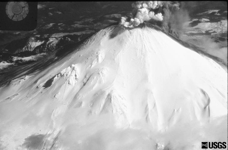 It was on March 27, 1980, that the first plumes of steam escaped from Mt. St. Helen’s. Just over seven weeks later, the mountain experienced a 5.1 earthquake which caused the north side of the volcano to slide away and triggered the largest debris avalanche in recorded US history.
 It was not until the April 23rd issue when I reported the first dusting of ash in Eatonville. Less than a month later the mountain blew.