Tag Archive | hiking

My Wawona

Like Yosemite National Park, it’s a treasure

October 1, 2024

A Tuesday Newsday Classic

Half Dome, Yosemite National Park, from Glacier Point overlook September 2015

October 1, 1890 marked the official inclusion of this region into the newly formed National Park System. Long before that, however, the Yosemite Valley had inspired the natives who resided in the area as well as the early white settlers.

It was, contrary to popular belief, James Mason Hutchings and artist Thomas Ayres who were the first Americans to tour the area in 1855.

From the Infallible Wikipedia:

“Hutchings and Ayres were responsible for much of the earliest publicity about Yosemite, writing articles and special magazine issues about the Valley. Ayres’ style in art was highly detailed with exaggerated angularity. His works and written accounts were distributed nationally, and an art exhibition of his drawings was held in New York City. Hutchings’ publicity efforts between 1855 and 1860 led to an increase in tourism to Yosemite.”

Although the greater Yosemite area had been set aside by Congress in 1864, the Valley and Mariposa Grove were ceded to California to manage as a state park. The two areas had seen an influx of homesteaders and were being rapidly commercialized as well as being used for the grazing of sheep and cattle; the old growth sequoias were being logged.

The iconic El Capitan

Most people associate the founding of Yosemite with early environmentalist John Muir. Rightly, he is credited with not only pushing for park expansion but also lobbied for the federal government to take back the iconic valley and grove.

Also from the Infallible Wikipedia:

“It was because of Muir that many National Parks were left untouched, such as Yosemite Valley National Park. One of the most significant camping trips Muir took was in 1903 with then president Theodore Roosevelt. This trip persuaded Roosevelt to return ‘Yosemite Valley and Mariposa Grove to federal protection as part of Yosemite National Park.’”

The years long efforts paid off when, in 1906, Roosevelt signed a bill which stripped the two areas still managed by California from the state and they were returned to the federal government which finally created a unified Yosemite National Park.

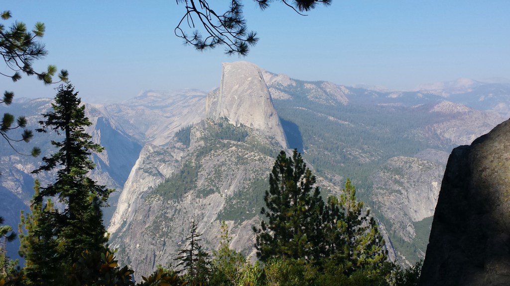
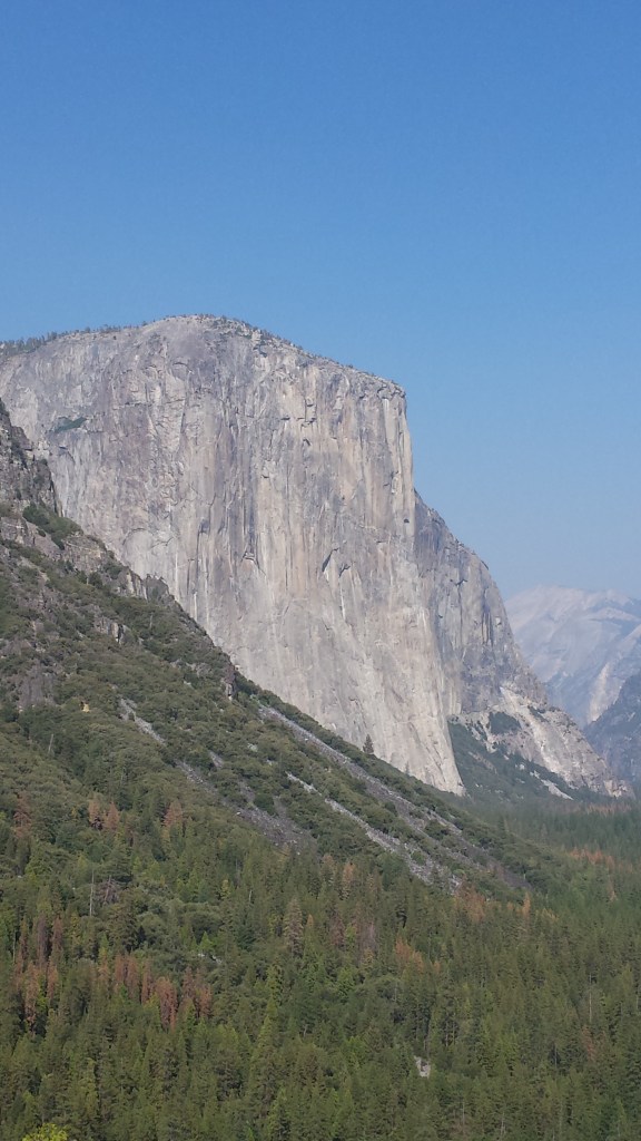
One trip to Yosemite is all it takes for a person to understand the grandeur and how special a place it is. From towering El Capitan, to the massive Half Dome, or the fascinating Tuolumne Meadows, Yosemite is a visual feast.

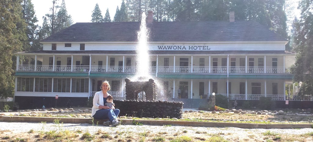
And the hubby and I wondered, when we visited in September 2015, how come it had taken us so long to get there. We arrived on the day after Labor Day which was a good thing as the summer crowds were gone. Reservations are generally required months – if not a year – in advance for the various hotels. I figured we were out of luck but checked anyway as we drove south a few days before our planned stay. What a surprise! There were rooms available at the Wawona Hotel or space in ‘dry’ tents. We opted for the hotel.

It was only after we arrived at the park that it dawned on me that the Wawona Hotel was nowhere near the Yosemite Valley. That day had turned into a driving ordeal. My hubby suffers from vertigo. Being close to any ledge can trigger a sensation of spinning as well as nausea. Knowing this, it was my duty to do the driving so that he could close his eyes as needed when navigating cliff-side roads.

The author, along with Alvin the Chipmunk traveling companion, at the Wawona Sept. 2015

Up, up, up we traveled from the eastern side of the park to the 9,943-foot-high Tioga Pass – the highest mountain pass in California. Come to find out, THAT was the easiest road. From there we wound our way through Yosemite’s high country. Then we had to go down. From Tuolumne Meadows – elevation 8,619 feet – to the Valley floor was a 4,619 foot descent. And all of it seemed to be a series of endless switchbacks and curvy roads carved in to the sides of mountains.

It was with a sense of relief we reached the bottom when it hit me… Wawona was another 30 miles which we had to add to the 230 we’d already traveled that day. No rest for the driver as the road climbed back up the other side through yet another series of switchbacks, cliffs, and amazing vistas.

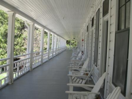
Now close to sunset, we found the hotel and were charmed at the thought of staying in an 1870’s structure.

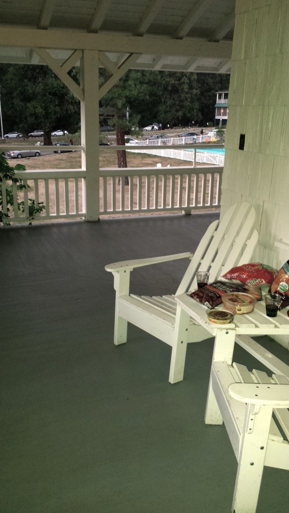
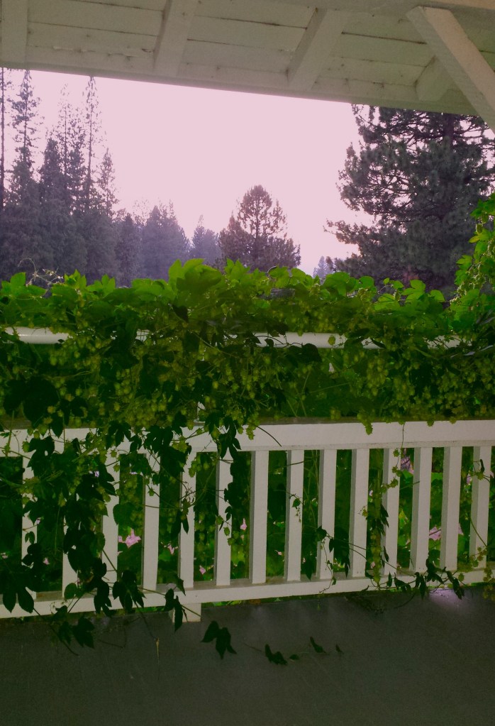
Our room was in the more recently added section… built at the turn of the last century. Located at the far western end of the first floor, the room opened out on to a wide veranda adorned with honeysuckle.

But that’s where the charm ended. The room itself featured a double bed and a twin bed. There was a sink attached to the wall next to the twin bed with a door in the wall next to it. The door, however, was locked.

Table for two on the verandah

The room was completed with a small square closet, small dresser and a table and chair. No TV and no phone. But we were up for the adventure and the price – less than $70 a night – was a steal even with having to use the bathroom down the stairs.

As we went to bed that night we could hear, through the thin walls, talking in the room next door; two men were conversing in German. We laughingly dubbed them Hans and Fritz and, although the hubby had taken German in high school, were unable to decipher their conversation.

The next day, after breakfast in the hotel dining room, we headed out for a full day of touring. That evening we bought deli meats, fruits, crackers, and a bottle of wine which we ate and drank while sitting in the Adirondack chairs outside our room on the veranda. A pink and purple sunset was the perfect icing on a wonderful day.

View to the west from the verandah outside our room

Despite the older beds and somewhat rustic accommodations we slept well… that was until about 7:30 the next morning when our German neighbors’ talking awoke us. It was then we discovered where the locked door next to the sink led. When the hotel was built, the rooms all shared Jack and Jill bathrooms. To accommodate a more modern customer the bathrooms had been designated as a private bath for one of the rooms only, and the door to the adjacent room was locked.

We had the room without a private bath. Our German neighbors, Hans and Fritz, had the bathroom. Did I mention that the walls were paper-thin and not insulated?

Soon, some rather unfortunate sounds penetrated into our hearing range. We dressed as quickly as we could and headed to breakfast… and decided that the Germans would hereafter be known as Fritz… and a scatological term which rhymes with Fritz.

Staying at the Wawona harkens back to a different time

Of course the thing one most recalls about any trip are the occurrences which are out of the ordinary. Our stay at the Wawona turned out to be the most memorable part. And we wouldn’t change a thing.

Update 2024: A few weeks ago it was announced that the Wawona Hotel would be closing for an indefinite period of time as they evaluate the structure. The news article said it needs a new roof but with some more in-depth evaluation the repairs could be more extensive.

A couple of websites to visit:
https://en.wikipedia.org/wiki/Yosemite_National_Park
https://en.wikipedia.org/wiki/Wawona_Hotel
For those who want to see the Wawona Hotel’s claim to fame, be sure to check out the movie “36 Hours.”
https://en.wikipedia.org/wiki/36_Hours_(1965_film)

Paricutin Volcano

Sometimes a volcano blooms overnight

February 20, 2024

A Tuesday Newsday Classic Updated

Geologically, nine years is a very short time period. But for farmer Dionisio Pulido of Paricutin, Mexico, the event which began at 4 p.m. on February 20, 1943, forever altered his life in a matter of moments.

Paricutin Volcano shortly after it first started erupting

As he is quoted in the Infallible Wikipedia:

“‘At 4 p.m., I left my wife to set fire to a pile of branches when I noticed that a crack, which was situated on one of the knolls of my farm, had opened . . . and I saw that it was a kind of fissure that had a depth of only half a meter. I set about to ignite the branches again when I felt a thunder, the trees trembled, and I turned to speak to Paula; and it was then I saw how, in the hole, the ground swelled and raised itself  2 or 2.5 meters high, and a kind of smoke or fine dust – grey, like ashes – began to rise up in a portion of the crack that I had not previously seen . . . Immediately more smoke began to rise with a hiss or whistle, loud and continuous; and there was a smell of sulfur.’

“He tried to find his family and oxen but they had disappeared so he rode his horse to town where he found his family and friends, happy to see him alive. The volcano grew fast and furiously after this. Celedonio Gutierrez, who witnessed the eruption on the first night reported:

‘…when night began to fall, we heard noises like the surge of the sea, and red flames of fire rose into the darkened sky, some rising 800 meters or more into the air, that burst like golden marigolds, and a rain like artificial fire fell to the ground.’”

And thus began an eruption which provided scientists an opportunity to study and record how a volcano is formed. During this time the volcano not only destroyed Pulido’s farm but forced the permanent evacuation of two towns, caused the deaths of three people (but not the farmer!), grew to 1,341 feet, and allowed scientists to witness the entire life cycle of a volcano.

Paricutin as it is today

Also from the Infallible Wikipedia:

“The importance of the Parícutin eruption was that it was the first time that volcanologists were able to fully document the entire life cycle of a volcano. The event brought geologists from all over the world,  but the principal researchers were William F. Foshag of the Smithsonian Institution and Dr. Jenaro Gonzalez Reyna from the Mexican government, who came about a month after the eruption started and stayed for several years. These two wrote detailed descriptions, drew sketches and maps and took samples and thousands of photographs during this time. Many of these are still used today by researchers. Foshag continued to study the volcano until his death in 1956. Between 1943 and 1948, almost fifty scientific articles were published in major journals about the volcano, with even more since. The worldwide effort to study Parícutin increased understanding of volcanism in general but particularly of scoria cone formation.”

It was quite likely I saw this documentary as a child and it was this that first sparked my interest in volcanoes. Some might call it an unhealthy obsession. But whatever it is I have a distinct memory of sitting in a darkened classroom and learning about this volcano.

Back in the 1960’s, every elementary school had an AV – that is Audio Visual – component. Manned by the kids who, today, rule the tech world, it was an unglamorous job (sort of like being a crossing guard or a hall monitor) which required said geeky boy (it was all boys at the time – just the way it was) to wheel the tall carts into classrooms and get it set up so the class could watch whatever educational program our teacher managed to snag so she (or he) could get a few minutes of down time. To be fair, WE unruly students loved those days also. But I digress.

Atop the cart which we had at Nob Hill Elementary in Yakima was a black and white TV connected by wires to a very crude version of video equipment. Once it was set up, off would go the lights and some item of interest would flicker to life.

While I couldn’t find a photo of the carts, we were all familiar with projectors that looked like this

As a child seeing a volcano literally grow out of the ground where it had just been a field was terrifying. Could that happen in MY backyard? Being that my natural state was to worry about such things I’m pretty certain I became quite concerned for my home. No doubt we learned about other deadly volcanoes: Mount Vesuvius, of course, and the most fascinating of all Krakatoa. Oh, and did I mention that on nice days I’d often see Mt. Adams – one of five Washington State volcanoes – off in the distance?

Of course my mother no doubt assured me that Mt. Adams was a dormant volcano and that Yakima was not prone to sudden volcanic eruptions and my family continued to live in blissful calm. It was only later in a college geology class that I learned Yakima sits on top of what is known as the Columbia River Basalt Group, which was a series of volcanic flows, that eventually covered about 81,000 square miles AND had depths up to 5,900 feet. That’s a whole lot of basalt which no one can take for granite… it was a gneiss fact to know.

Of course that was millions and millions of year prior, so of course there was no danger. Well, that was until May 18, 1980… when THAT myth was blown to pieces. I might have covered stubby Mt. St. Helens in another Tuesday Newsday article or two.

Volcan de Colima – aka Volcan de Fuego or the English translation ‘Fire Volcano’. Photo taken by my son in late January.

A couple of years ago our son moved to Guadalajara, Mexico. And until recently I hadn’t thought much about Mexican volcanoes. Of course I did know that the Pacific ring of fire which, in addition to being earthquake prone, also had a few volcanoes…913 to be exact. Whoa.

Mexico, specifically the region which stretches from the Pacific Ocean to the Caribbean Sea which starts near Puerto Vallarta and extends east to Guadalajara and then Mexico City and ending just north of Veracruz, has 23 of these volcanoes in a region known as the Trans-Mexican Volcanic belt.

So now I have new volcanoes to worry about. Of course I shouldn’t be concerned that Volcan de Colima, also known as Volcan de Fuego, is a mere 78 miles from where my son now lives. Or that Volcan de Fuego erupted as recently as January 2017. Or that our son went hiking on neighboring volcano Nevado de Colima – which is 3 miles north of Volcan de Fuego – in January of this year. I’m sure there’s nothing to worry about!

A map showing the location of the 23 volcanoes which define the Trans-Mexico Volcanic Belt
My son on his recent hike to Volcan Nevado de Colima in front of the ‘you have arrived’ sign

For reference, Paracutin is much, much further away from Guadalajara, more like 150 miles how the crow flies. The next time I’m in Mexico I plan to take a much closer look at the landscape to see how many of Mexico’ volcanoes I can identify.

For those who want to learn more:

https://en.wikipedia.org/wiki/Par%C3%ADcutin

Not sure if this is the video I saw but the music alone is enough to instill terror into a child….

And a few more articles and linkes about one of my favorite topics:

https://en.wikipedia.org/wiki/Columbia_River_Basalt_Group

https://en.wikipedia.org/wiki/Volc%C3%A1n_de_Colima

https://en.wikipedia.org/wiki/Volc%C3%A1n_Nevado_de_Colima_National_Park

https://en.wikipedia.org/wiki/Ring_of_Fire