The Great Quake
January 26, 2021
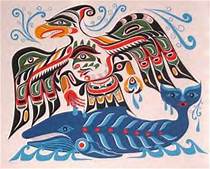
“There was a great storm and hail and flashes of lightning in the darkened, blackened sky, and a great and crashing ‘thunder-noise’ everywhere. Here were also a shaking, jumping up and trembling of the earth beneath, and a rolling up of the great waters.”
So the oral story of the Hoh people had been told, passed down from generation to generation. The event, it turns out, was not the stuff of fiction but can be pinpointed to the night of January 26, 1700.
It was at that moment, triggered by a sudden unlocking of the Juan de Fuca and North American geologic plates, that a estimated 9.2 earthquake shook the west coast from Northern California to Southern British Columbia.
The earthquake triggered a huge tsumani which inundated the coast, wiping out entire villages of people, submerging land, and killing forests.
And then? And then only the oral stories remained and were passed down. But when new people arrived nothing was known of this event until the 1970’s when geologists started piecing together the geologic history.
From the Infallible Wikipedia:
“The earthquake took place at about 21:00 Pacific Time on January 26, 1700 (NS). Although there are no written records for the region from the time, the timing of the earthquake has been inferred from Japanese records of a tsunami that does not correlate with any other Pacific Rim quake. The Japanese records exist primarily in the modern-day Iwate Prefecture, in communities such as Tsugaruishi, Kuwagasaki and Ōtsuchi.
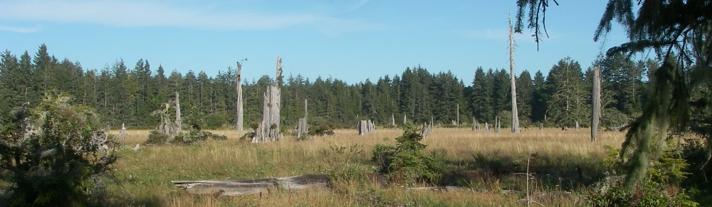
The most important clue linking the tsunami in Japan and the earthquake in the Pacific Northwest comes from studies of tree rings (dendrochronology), which show that several ‘ghost forests’ of red cedar trees in Oregon and Washington, killed by lowering of coastal forests into the tidal zone by the earthquake, have outermost growth rings that formed in 1699, the last growing season before the tsunami. (snip)
Local Native American and First Nations groups residing in Cascadia used oral tradition to transmit knowledge from one generation to the next, so there is no written documentation like that of the Japanese tsunami. However, numerous oral traditions describing a great earthquake and tsunami-like flooding exist among indigenous coastal peoples from British Columbia to Northern California. These do not specify an exact date, and not all earthquake stories in the region can be definitively isolated as referring to the 1700 quake in particular; however, virtually all of the native peoples in the region have at least one traditional story of an event much stronger and more destructive than any other that their community had ever experienced.”
This forensic information, combined with the Japanese records, have made it possible to pinpoint the date and time of the great event.
Ground Zero seems to be located at the mouth of the Copalis River, just north of Gray’s Harbor in Washington State. The ghost forest appears at low tide. It’s been determined that the ground dropped over 6 feet and that the trees all died as a result of a singular event. Through carbon dating and evaluation scientists now know that the event occurred in either late 1699 or early 1700.
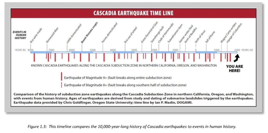
But it wasn’t just a onetime thing. Scientists have also found evidence that over 40 megathrust quakes have shaken the PNW in the past 10,000 years. That, it turns out, means an average of 430 years between the quakes. The three most recent events occurred in 810, 1310, and 1700. It’s now been 321 years since the 1700 event. Scientists predict that there is a 37 percent chance of an 8.2 or greater quake in the next 50 years.
For those of us who have lived our entire lives in the PNW, we know exactly where we were and what we were doing on two specific dates in the last 50 years: April 29, 1965 and February 28, 2001.
Those were the dates of the most significant ‘recent’ earthquakes in the region. I was seven years old for the first one and, prior to that April morning, had never heard the term earthquake or understood what it was.
I was standing at the counter in our family bathroom (we had one bathroom for six people!) and my mother was fixing my hair for school. We lived in Yakima, 150 miles from the quake’s epicenter. When the house started to shake my mother, so very calmly, said to me, “It’s an earthquake,” and instructed me to hang on to the counter. Soon that event was forgotten but everyone of my age or older knows where they were at that exact moment, especially people who lived in the Puget Sound area.
Fast forward to February 28, 2001. It’s just before 11 a.m. The kids are at school and I have spent the morning volunteering with my fifth grade son’s class. Around 10:30 – when two other parents arrive – I take off as I have errands to run in advance of the Boy Scouts Blue and Gold banquet scheduled for March 2nd.
When I arrive back at our house on the hill above East Lake Sammamish parkway, my in-laws are there as they have been staying with us for a few days. I tell them that I’m going to have something to eat then go do my errands. I walk to the fridge and open the door. There’s a significant jolt. I shut the fridge door and look up and say “Did you…” to my father-in-law who is standing a few feet away. But I never finish the sentence. By then the entire house is shaking. So I do what my plan has always been in the event of an earthquake. I hurry to our built in desk, move the chair out of the way, and crawl under.
When I turn to look out I see two things: first is my mother-in-law who is sitting on the couch and looks as if she’s bouncing in a boat on choppy water; the second thing I see are my father-in-laws legs getting bigger and bigger until the legs and him attempt to crawl under the desk with me. Trust me, it was not a big desk and that plan did not work. Instead, he ended up crouched next to me until the worst of the shaking stopped after about a minute.
I emerge and look out the back windows; trees are still vibrating and shaking despite the quake being over. Of all the memories of that day, I can still see those trees vibrating. Then I walk around the house to see what’s been damaged. Room after room nothing seems to have fallen… that is until I get to the living room. The painting which hung over the fireplace has slid off the wall and come straight down onto the mantle. There it rests, still intact and literally resting behind a decorative glass piece which, by rights, should have been a casualty of the event.
Later that evening I have the assembled family stage a photo to commemorate that day and soon that quake is also forgotten.

It’s on days such as today, however, that I am reminded that the ‘big’ one could strike today, tomorrow, next week, next year, or longer. It really is just a matter of time.
Many links for all my fellow science nerds:
https://en.wikipedia.org/wiki/1700_Cascadia_earthquake
https://www.atlasobscura.com/articles/pacific-northwest-prepares-for-massive-earthquake
https://en.wikipedia.org/wiki/1965_Puget_Sound_earthquake
https://en.wikipedia.org/wiki/2001_Nisqually_earthquake
Here’s the list of Great Quakes from the Infallible Wikipedia:
| 1 | May 22, 1960 | Valdivia, Chile | 1960 Valdivia earthquake | 9.4–9.6 |
|---|---|---|---|---|
| 2 | March 27, 1964 | Prince William Sound, Alaska, United States | 1964 Alaska earthquake | 9.2 |
| 3 | December 26, 2004 | Indian Ocean, Sumatra, Indonesia | 2004 Indian Ocean earthquake | 9.1–9.3 |
| 4 | March 11, 2011 | Pacific Ocean, Tōhoku region, Japan | 2011 Tōhoku earthquake | 9.1[3] |
| 5 | July 8, 1730 | Valparaiso, Chile (then part of the Spanish Empire) | 1730 Valparaiso earthquake | 9.1–9.3 (est.)[4] |
| 6 | November 4, 1952 | Kamchatka, Russian SFSR, Soviet Union | 1952 Kamchatka earthquakes | 9.0[5] |
| 7 | August 13, 1868 | Arica, Chile (then Peru) | 1868 Arica earthquake | 8.5–9.0 (est.) |
| 8 | January 26, 1700 | Pacific Ocean, US and Canada (then claimed by the Spanish Empire and the British Empire) | 1700 Cascadia earthquake | 8.7–9.2 (est.) |
| 9 | April 2, 1762 | Chittagong, Bangladesh (then Kingdom of Mrauk U) | 1762 Arakan earthquake | 8.8 (est.) |
| 10 | November 25, 1833 | Sumatra, Indonesia (then part of the Dutch East Indies) | 1833 Sumatra earthquake | 8.8 (est.) |
